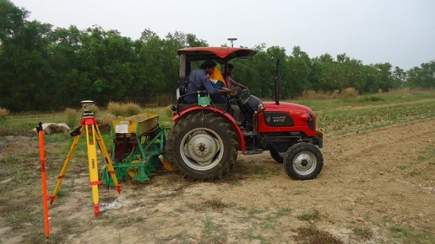
IIT Kharagpur researchers have developed a novel Differential Global Positioning System (DGPS)-enabled soil mapping based technology (an application and tractor based device) to improve the efficiency in the application of fertilizers in agricultural lands with data computed from the soil map in real-time. Geospatial mapping is a buzzword with the Government of India liberalizing the sector.
There is another side of mapping that could transform the food security program of India; soil maps which could be accessed using differential GPS, developed by researchers at IIT Kharagpur for a variable rate of fertilization application in farmlands. The novel technology is aimed towards efficient use of Nitrogen, Phosphorous and Potash for automated soil nutrition management by bypassing both manual labour based operations or sensor-based fertilization technologies which are still under development.
Spatial variations in soil type and mineral content in large agricultural tracts are a common phenomenon that leads to a dynamic need for resources such as fertilizers, pesticides, herbicides and even water. Farmers have been collecting information on these variations through soil tests by local bodies or installing sensors to collect the data in real-time. However, the proximity of the applicator vehicle to the sensor hinders real-time sensor-based data processing and fertilizer application.
Prof VK Tewari, director, IIT Kharagpur along with his former research scholar Dr Sneha Jha from the Department of Agricultural and Food Engineering explored an alternate method of creating a soil nutrition map that can be accessed in real-time through differential global positioning system for variable rate application of NPK.
Explaining the process Prof Tewari said: “We divided one hectare of land into 36 grids with the nutritional requirement of each grid fed in the soil map. The fertilizer applicator vehicle, fitted with a DGPS module and GUI enabled Microprocessor cum Microcontroller, can access this map and compute in real-time the variable rates in the fertilizer application function.”
The soil map can be replicated for agricultural plots based on soil tests which can be performed at district administration levels or by private labs. This data when fed into the DGPS module will be accessible to farms using the GUI installed-applicator.
“The system can detect the field grids in real-time with a length-wise accuracy of 16 cm towards the east and breadth-wise accuracy of 20 cm towards the north. It can manage the automated application from 5 to 400 Kg per hectare. Application of such desired amount of NPK precisely at a specific location will enhance crop production and avoid environmental degradation,” said Prof. Tewari.
“This technology would be able to reduce 30% of fertilizers used in manual methods thus ensuring substantial savings in resource applications,” he further added remarking on how this technology can bring the cost of fertilizer application by improving the efficiency of the job and reducing manual labour.

