Now create optimized site designs, with Bentley’s new SITEOPS workflow leveraging reality meshes created with ContextCapture and stunning visualizations created with Bentley LumenRT as part of the design process. With ContextCapture, users can create highly accurate 3D reality meshes containing the precision to allow any engineering project to be done completely in context. These reality meshes are engineering ready and can now be directly used as context for 3D design, with the most accurate topography possible, within SITEOPS. Once the design is complete, users can export the 3D model to Bentley LumenRT for creating amazing, enlivened 3D visualizations.
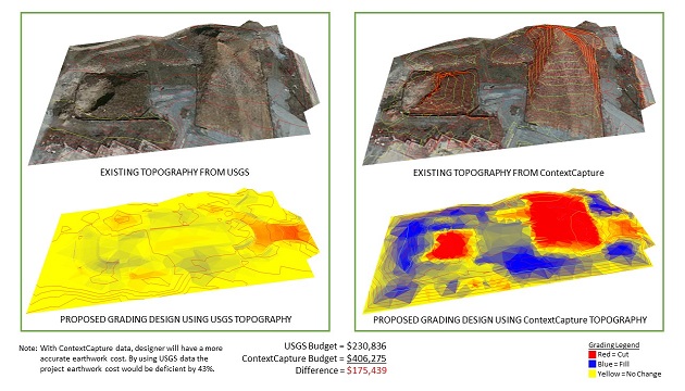
The hardest part of creating a site plan and design is to acquire an accurate and complete survey of the existing conditions. Context Capture allows designers to quickly produce accurate terrain models from a collection of ordinary digital photographs, which can be immediately used in SITEOPS to begin the process of identifying optimal site configurations.
Key new capabilities include:
- Acquire detailed existing surface topography from digital images for use in grading design and analysis;
- Conduct site feasibility studies by using digital imagery, computational design tools, and cost optimization in a fraction of the time it normally takes using traditional CAD software;
- Analyze multiple site layouts and grading plans using the digital topography produced by ContextCapture to determine the best design options based on constraints and cost of construction;
- Combine the most cost-effective layout and grading with enlivened digital content such as buildings, trees, vehicles, and more to bring projects to life with Bentley LumenRT;
- Create stunning 3D visualizations that will allow design professionals to convey the intent of their designs to project stakeholders
When determining the construction budget, one of the biggest risks is typically in the cost of grading, due to the lack of quality data in the conceptual stage and the time it takes to perform grading designs. Now, with ContextCapture, users can turn site photos into detailed topography, replacing the low quality surface data with high-quality detailed reality meshes. This workflow allows design firms to determine optimal design options based on accurate data enabling the client to make a better decision sooner in the project lifecycle.
Phil Christensen, VP, analytical modeling, Bentley Systems, said, “The integration of ContextCapture reality meshes into SITEOPS extends the dramatic positive impact that drones are having on civil teams that work on site optimization. These teams can now benefit from the automatic conversion of photos to meshes that ContextCapture provides and more rapidly identify optimal site configurations from an accurate, up-to-date terrain model.”


